Custom GPX Route Map
A laser-engraved map of a route you actually rode, hiked, ran, or paddled. You send us the GPX file from your watch, bike computer, or mapping app; we engrave the route — optionally over contour lines and named landmarks — onto a wood panel sized to drop straight into an off-the-shelf frame.
What We Need From You
During the Etsy order, please fill out the follwing:
- Title and subtitle — for example, Kokopelli Trail over Fruita, Colorado.
- Size — see Sizes.
- Units — miles and feet, or kilometers and meters.
- Topo contours and landmark labels — yes or no on each. See Map Options.
- Stand Options - choose whether to include a laser cut stand for the plaque.
- GPX file - Either add a public link to a workout or send to [email protected] with your order number:
When exporting a friends activity the time data may not be included. We may need you to send the calendar date and the length of the activity.
Sizes
Plaques are cut to standard photo frame dimensions in case you want to frame it, but these plaques do not require a frame. Frames are not included.
| Size | Dimensions | Notes |
|---|---|---|
| 4" × 6" | 101.6 × 152.4 mm | Desk and shelf scale |
| 8.5" × 11" | 215.9 × 279.4 mm | US Letter — the wall-art size |
Which size should I pick? The route, the elevation profile, and the stat line read well at both sizes. Contour lines also work at both. Landmark labels are really an 8.5" × 11" feature — peak and town names are engraved at a minimum legible size, and on a 4" × 6" panel there simply isn't room for many of them before they'd overlap. If named peaks matter to you, go with the larger size.
Materials
- 3 mm basswood plywood — a light, even, close-grained face that takes fine engraving cleanly.
- Cut and engraved on a laser. There is no ink, paint, or vinyl involved; the dark lines are the wood itself.
- The back of every panel carries our logo, our web address, where it was made, and the map data credits.
Every panel is a one-off cut from your own GPS data, so small variations in grain and engraving tone between pieces are normal and are part of the material.
Map Options
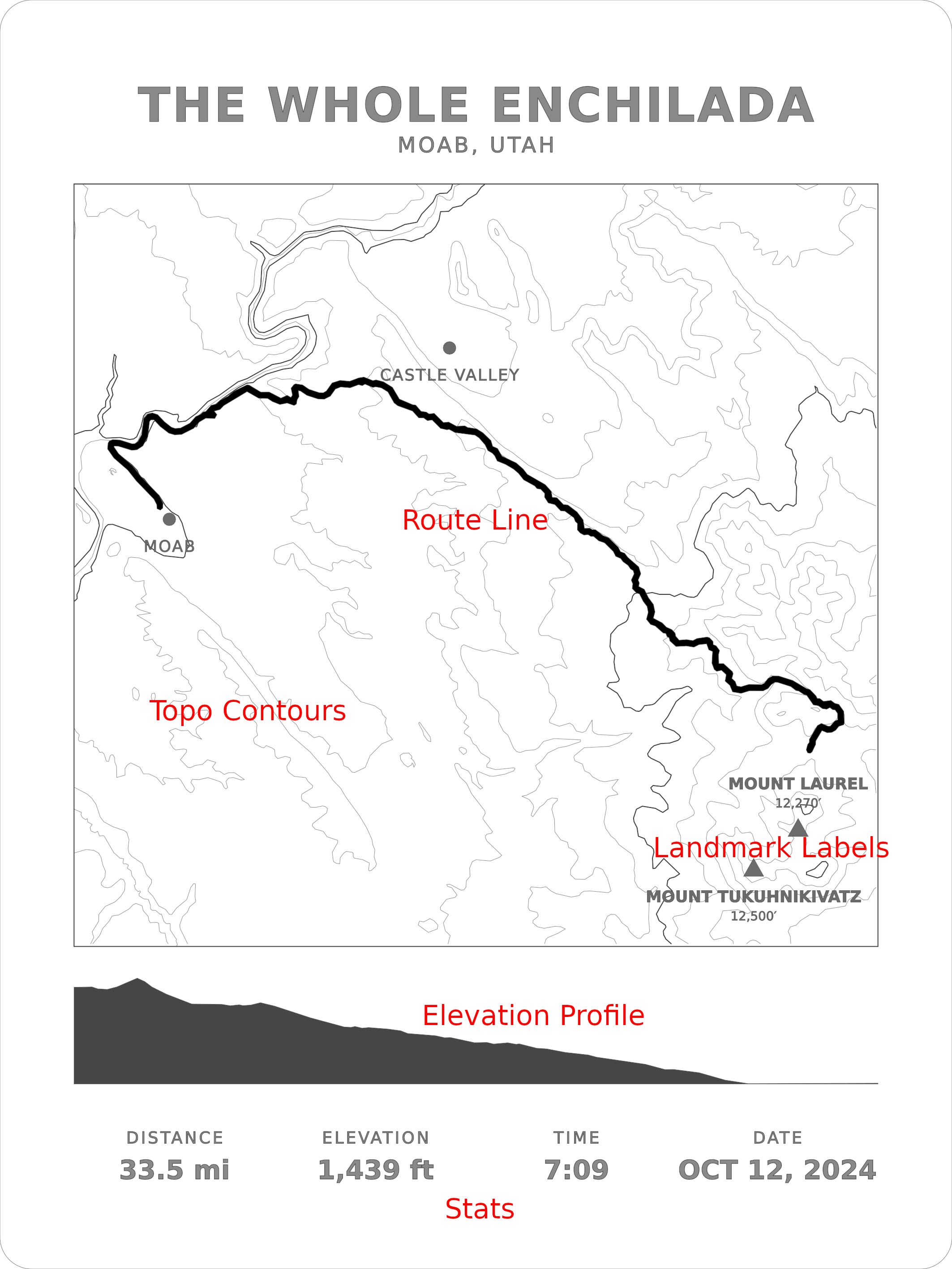
| Option | What it adds |
|---|---|
| Route line | Always included — your track, drawn as a bold line |
| Elevation profile | Always included — the climb-and-descent chart beneath the map |
| Stats | Always included — distance, elevation gain, elapsed time, and date |
| Topo contours | Contour lines generated from real elevation data for the area your route covers |
| Landmark labels | Named peaks with elevations, towns, lakes, and rivers near your route |
Flat routes make quiet topo maps. Contour lines come from the actual terrain, so a ride across the plains produces few contours or none at all — that's real geography, not a defect. If your route is flat and you want a fuller-looking panel, the plain route version usually looks better than the topo version. We will always send a preview prior to cutting and we can add/remove options for you.
Getting Your GPX File
Any .gpx file works. It can be a recorded activity (a track) or a planned route. If your app only exports TCX, FIT, or KML, send it anyway — we can usually convert it.
Rather than duplicate instructions that change whenever these apps update, here are the official guides:
| Source | Guide |
|---|---|
| Strava | Exporting your data — on an activity page, use the ⋯ menu → Export GPX. To export someone else's public activity, see Downloading a GPX route from another athlete's activity. |
| Garmin Connect | How do I export data out of Garmin Connect? For a planned course rather than a recorded ride, see How to share or export a course. |
| AllTrails | Downloading files from AllTrails — choose GPX Track if offered the choice. |
| Ride with GPS | Export file formats — choose GPX Track. |
| komoot | Export and import routes and activities |
| Gaia GPS | Export data as GPX, KML, or GeoJSON |
| Trailforks | How do I download or export trail data? |
| onX Backcountry | Importing and exporting markups — export your item as a GPX track. |
| Wahoo ELEMNT | ELEMNT computers save completed rides as FIT files, not GPX. The simplest path is to let the ride sync to Strava or Ride with GPS and export the GPX from there. |
| Apple Watch / Apple Fitness | Apple has no built-in GPX export. Either export your full Health archive (Health app → your profile picture → Export All Health Data), which includes a workout-routes folder of GPX files, or use a third-party app such as GPX Export, HealthFit, or WorkOutDoors. |
Not listed here? Nearly every GPS watch, bike computer, and mapping app can export GPX somewhere in its share or download menu. Send us whatever file you can get and we'll tell you if we can use it.
Choose a GPX Track over a GPX Route when an app offers both. A track is the full recorded breadcrumb trail and draws the shape you actually traveled; a route is a sparse list of turn points and can come out looking angular.
Product Care
- Dust with a dry or barely damp cloth. Nothing abrasive, no solvents, no furniture polish.
- Keep it dry. This is thin plywood — standing moisture and humid rooms will warp it, so it is not suited to bathrooms, kitchens over a stove, or outdoors.
- Keep it out of prolonged direct sunlight. Like all light woods, basswood darkens over time in strong sun and the engraving contrast will fade with it.
Map Data and Credits
Contour lines are derived from public-domain SRTM/USGS elevation data.
When landmark labels are included, the place names come from OpenStreetMap:
Map data © OpenStreetMap contributors, available under the Open Database License (ODbL). openstreetmap.org/copyright
That credit is engraved on the back of every panel that uses it. It is a licensing requirement, not decoration, so it can't be removed — but it lives entirely on the reverse face and is invisible once the piece is framed.
FAQ
How long can my route be? There's no practical limit. Multi-day tours, thru-hikes, and hundred-mile rides all work. Longer routes cover more ground, so the map zooms out and fine detail gets smaller — a huge route on a 4" × 6" panel will read as an overall shape rather than a trail you can trace turn by turn.
Can you combine several GPX files into one map? Yes — send them all and tell us how you'd like them handled. A multi-day trip recorded as one file per day is a common request.
Can I use someone else's route? Yes, as long as it's a public route you can legitimately download — a race course, a classic trail, a friend's shared activity. It doesn't have to be your own recording. Note that sometimes a download from a public route may be missing data, we may ask you to fill this in during production.
Will my home address be visible on the map? The map shows whatever is in the GPX file, so a ride that starts at your door shows a line starting at your door. If that matters to you, either trim the file before sending it or tell us where to trim, and we'll cut the start and end back for you.
Can I get a different size, or a wood I don't see listed? Ask. The larger sizes are limited by our laser's cutting envelope, but there's room between 4" × 6" and 8.5" × 11" and other stock is sometimes available.
Does it come framed or ready to hang? No. It ships as a flat panel cut to standard frame dimensions, so you can choose a frame that suits your wall. For hanging directly on the wall we recommend 3M command strips or similar.
Can I get the design file? We don't sell or send the source files.
Troubleshooting
The elapsed time on my panel looks too long The time shown is total elapsed time — the gap between the first and last GPS point — not moving time. A ride with a long lunch stop reads high. Tell us if you'd rather we leave the time off, or let us know what time you would like engraved.
My distance or elevation gain doesn't match my app exactly Small differences are expected. Every platform smooths GPS and barometric noise a little differently, so distance can vary by a fraction of a percent and elevation gain by more than that. We calculate from the raw points in your file. If you'd prefer the numbers to match your Strava or Garmin screen exactly, send us the figures you want and we'll engrave those.
Part of my route is missing Two usual causes. Either the recording had a GPS dropout or the watch paused, which leaves a real gap in the file — check whether the track looks complete in the app you exported from. Or, if you use privacy zones on Strava, the hidden section near your home may have been stripped out of the export. Either way, send us what you have and we'll show you the shape before cutting.
My route looks angular or has straight shortcuts across corners That's the signature of a GPX Route rather than a GPX Track — routes store only turn points. Re-export as a track if your app offers the choice.
The peak I wanted isn't labeled Labels are only placed where they can be read: a name that would run off the panel, collide with another label, or sit on top of the route line is dropped rather than engraved illegibly. Smaller panels fit fewer labels. Tell us which peak you specifically want and we'll make room for it, usually by dropping a less important one.
Returns
Because each map is engraved from your own GPS data, these are made-to-order personalized items and are not returnable once cut. If your panel arrives damaged, or what we engraved doesn't match what you asked for, contact us and we will make it right.
We will always show you a preview of the layout before cutting if you ask — the easiest way to avoid a surprise.
If you have any questions or run into issues, reach out to us at [email protected].